Hot


Related Products


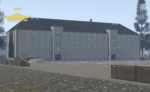
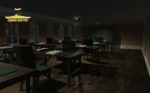
Bastia, Corsica
Bastia is located on the island of Corsica, the same island on which Napoleon was born before his rise to glory. This is a lovely feature map built by an incredible developer known as "Enzoneistat". This map has many features; it could be used as a European/French roleplay map or used to simulate apocalyptic-type scenarios. The versatility of this map knows no bounds!


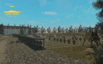
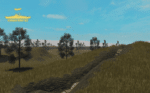
Battle of Ypres 1917 Map V2
Introducing our meticulously crafted Battle of Ypres 1917 Map – a historical treasure that brings one of the most iconic World War I battles to life. Immerse yourself in the past with this detailed map based on Ypres from the 1917 movie, this lovely huge map is wonderful for all your WW1 needs! This is a further add on with increased detail, new locations, expanded town and new trenches.


Reviews
Clear filtersThere are no reviews yet.